1.- ROUTE DESCRIPTION
To sail Southbound or Northbound from Cape Horn (Cabo de Hornos) to Chacao Channel, there are two main routes; first, the Ocean Route that does not need any special explanation and the Inner Channels Route. The Inner Channel Route offers different alternatives and it is highly recommended in bad weather conditions, which are very common in the area. Furthermore, it provides a great opportunity to visit uniquely beautiful places, with glaciers, waterfalls, inlets, as well as flora and marine fauna.
All inner channel routes are well signaled and do not present great navigation difficulties. All navigable passages have good and updated charts. The Chilean Hydrographic Office www.shoa.cl (Servicio Hidrográfico y Oceanográfico de la Armada de Chile SHOA), a MIO member, publishes and updates all national charts, used for sailing Chilean waters.
In order to provide safe sailing and to coordinate vessels transit, the Chilean Maritime Authority has established transit regulations for crossing certain passages. These rules set periods of the day for transit, if required, as well general recommendations for a safe navigation. The latter are shown at Paragraph 3. - SAILING REGULATIONS.
Descriptions of the alternative routes throughout Chilean channels, straits and fiords are shown in the following graphs:
| * Figure Number 1: | It shows all routes between Chacao Channel and Strait of Magellan (Estrecho de Magallanes). |
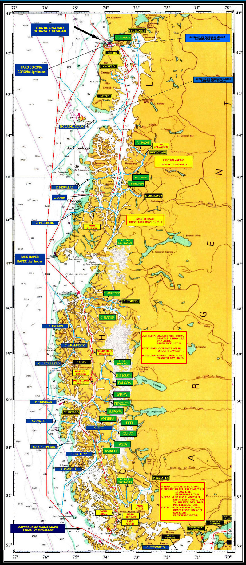
| * Figure Number 2: | It shows channel routes of Chiloé area, between Chacao Channel and Golfo de Penas - (Raper Lighthouse - Faro Raper - Latitude 46 50 S). |
| * Figure Number 3: | It shows Patagonian Channels routes (Canales Patagónicos) between Golfo de Penas and Strait of Magellan (Estrecho de Magallanes). |
| * Figure Number 4: | It shows Fueguinos's Channels routes (Canales Fueguinos) between Strait of Magellan (Estrecho de Magallanes) and Cape Horn (Cabo de Hornos). |
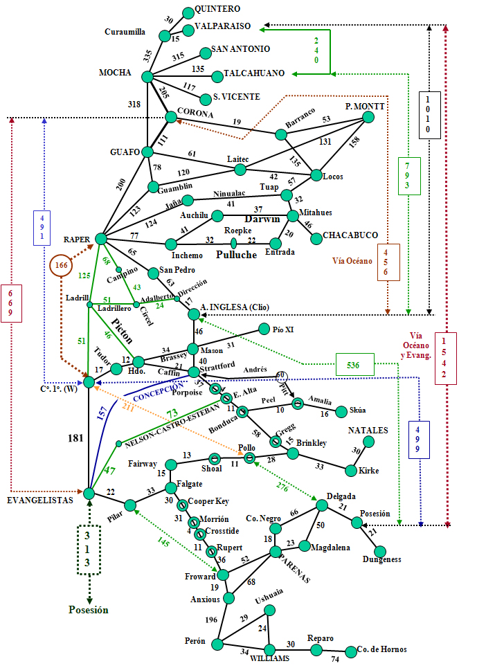
Figure Number 1, Routes between Chacao Channel and Strait of Magellan (Estrecho de Magallanes):
Red color: |
Normal or more used route for sailing between Chacao Channel and Strait of Magellan. |
Blue Color: |
Ancud Pilot Station, for vessels with up to 180 meters LOA and 10 meters of draught (embarking) and up to 200 meters LOA and up to 10 meters of draught (disembarking), and Laitec Pilot Station, for vessels with more than 180 meters LOA (embarking) and with more than 200 meters LOA (disembarking). |
Yellow color: |
Rules or restrictions to certain passages |
Light Blue color: |
Other alternative routes |
FIGURE NUMBER 1:ROUTES BETWEEN CHACAO CHANNEL AND STRAIT OF MAGELLAN
1.- SOUTHBOUND ALTERNATIVE ROUTES :
a) For vessels with up to 180 meters LOA and up to 10.7 meters Draught.
(Restriction for English Narrow)
- This type of vessels can safely sail the whole route of Chiloé area, between Chacao Channel and Darwin Channel, with a total length of 282 nautical miles (See Figure N° 2)
- Vessels with up to 180 LOA can also use Patagonian Channels (Canales Patagónicos) routes, between Messier Channel (San Pedro Lighthouse - Faro San Pedro) via English Narrows (Angostura Inglesa), continuing troughout Guia Narrows (Angostura Guía), Gray Channel or Summer Passage and finally Shoal passage to reach Strait of Magellan. Another alternative is to sail troughout Fallos Channel (Campino Lighthouse) via Trinidad Channel, Guia Narrows, Gray Channel or Summer Passage and finally Shoal passage. Entering troughout Messier Channel the route has a length of 358 nautical miles, while using Fallos Channel the total length is 382 nautical miles. (See Figure N° 3).
- In summary, vessels with up to 180 meters LOA and up to 10.7 meters draught can sail up to 640 nautical miles trough inner waterways.
b) For vessels with up to 230 meters LOA and up to 12 meters Draught in low water.
(Restriction for Gray Channel)
- These vessels can safely sail the whole route of Chiloé area, between Chacao Channel and Darwin Channel, with a total length of 282 nautical miles (See Figure N° 2)
- Furthermore, they can use Patagonian Channels routes from Fallos Channel (Campino Lighthouse) to Strait of Magellan, via Trinidad Channel, Guia Narrows, Gray Channel and Shoal passage, with a total length of 382 nautical miles (ocean and channel routes) and 331 nautical miles of inner channels route only. (See Figure N° 3).
- An alternative, to avoid waiting for daylight in order to cross Gray Channel, is to exit to an ocean route and enter the Strait of Magellan via Esteban Channel and Nelson Strait. This means a sailing of 163 nautical miles within inner channels and 47 nautical miles of ocean navigation.
c) For vessels more than 230 meters LOA and more than 12 meters Draught in low water.
- These vessels can safely sail the whole route of Chiloé area, between Chacao Channel and Ninualac or Darwin Channels, with a total length of 259 nautical miles if Ninualac channel is used. (See Figure N° 2)
- In Patagonian Channels route they can sail from Fallos Channel (Campino Lighthouse) to Strait of Magellan, via Trinidad Channel, Inocentes Channel, Guia Narrows, Esteban Channel, Castro Chanel and Nelson Strait, with a total length of 304 nautical miles (ocean and channel routes) and 253 nautical miles of inner channels route only. If current and wind conditions are favourable at Guia Narrows area, Andrés and Pitt channels can be used as an alternative. (See Figure N° 3).
- The latter route has been used by supertankers and passenger vessels with near 300 meters LOA (tanker NORDIC FREEDOM with 274 meters LOA and the passenger cruiser STAR PRINCESS with 290 meters LOA, beam of 36 meters and GRT of 109.000).
d) Fueguino's Channels (Canales Fueguinos) and route to Cape Horn (Cabo de Hornos).
- All vessels can sail the Fueguino's Channels route, between Strait of Magellan and Cape Horn, troughout the following channels: Magdalena, Cockburn, Unión, Ballenero, O´Brien, Norwest Branch of Beagle Channel and the Beagle Channel proper.
PASSENGER CRUISER "STAR PRINCESS" IN PORT

TANKER "NORDIC FREEDOM"
CROSSING GUIA NARROWS (ANGOSTURA GUIA)
FIGURE NUMBER 2:ROUTES IN CHILOE AREA - BETWEEN CHACAO CHANNEL AND RAPER LIGTHOUSE ( GOLFO DE PENAS)
a) ANCUD Pilot Station (for Chacao Channel routes) for vessels with up to 180 meters LOA and up to 10 meters draugth (embarking) and with up to 200 Meters LOA and up to 10 Meters draught (disembarking). Larger vessels and with more draught may enter to Chacao channel only if Pilots are already on board. (Previously embarked at any of the following ports: Los Vilos, Quintero, Ventanas, Valparaíso, San Antonio, San Vicente, Coronel, Bahía de Concepción or Corral)
b) LAITEC Pilot Station for vessels with more than 180 Meters LOA (embarking) and with more than 200 Meters LOA (disembarking).
c) The red route is the normal shipping route and has no restriction for vessels less than 59 meters of air draught in high water at Chacao Channel.
d) The blue route shows the different sailing options. See restrictions in the following paragraph 3.
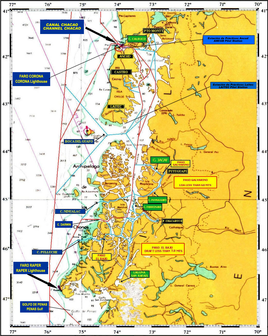
FIGURE NUMBER 3: PATAGONIAN CHANNELS (CANALES PATAGÓNICOS) ROUTES - BETWEEN GOLFO DE PENAS AND STRAIT OF MAGELLAN
a).Patagonian channels present a number of interesting sailing passages, such as: the English Narrows (Angostura Inglesa), Abismo Passage (Paso del Abismo), Guia Narrows (Angostura Guía), Gray channel, Shoal Passage (Paso Shoal) and many others.
b).The Light blue color route shows the differents sailing option, and also the access to different glaciers of Andes Mountain Range - Southern Ice Fields, which are a special attraction for passenger and scientific vessel.

FIGURE NUMBER 4:ROUTES BETWEEN STRAIT OF MAGELLAN (ESTRECHO DE MAGALLANES) AND CABO DE HORNOS
a). Fueguinos's channels (Canales Fueguinos) present a number of glaciers in the North eastern and South Eastern Beagle Channel branches. These channels are the main inner water route to reach Cabo de Hornos and the Antarctica.
b). The channels can be sailed by large vessels

2.- PILOTING FEES:
See "Piloting Fees" (Separation A, number 6).